
Report on the visit to Kuizhimake and Santa Marta (February 14–18, 2026)
Ingrid Olivares & Rodrigo Cámara-Leret
This report details the activities carried out together with our Kogui friends who live in Kuizhimake in the Cañas River basin, as part of the “Munekan Masha” initiative in collaboration with the Tairona Heritage Trust.
Broader context
As the highest coastal mountain range, the Sierra Nevada de Santa Marta (SNSM) harbours exceptional biological diversity across steep climatic and elevational gradients including at least 1,800 species of flowering plants, 184 mammals, and more than 600 bird species (Cleef, 1984; Cleef & Rangel, 1984). About 35 main rivers originate in the SNSM, which characterise the region by abundant water availability. However, the SNSM has experienced increasing hydrological stress due to glacial retreat and land degradation, culminating in altered precipitation regimes that range between acute water shortages and heavy stormy periods in recent years.
In this trip we got to discuss and experience along with the Kogi the importance of recovering land in the lowlands. As ecologists we have basically the same interpretation of how the water that flows through the rivers originates in the lowlands. Clouds are the product of the evapotranspiration from the ocean and the vegetation of the lowlands. These clouds move towards the mountain and precipitate as rain once they cool down. That rain gives rise to ice high up in the peaks and to rivers along the slopes, the same rivers that flow down till they reach the coast. The Kogi speak of the links that connect all the elements along and across their lands, and how these links need to be cared of and fed to compensate for what we consume, and to avoid the disappearance of animal, plants, or elements of the habitat, like humidity or soil nutrients. Such links and relationships are a concept that we also recognise as the “network of ecological interactions”.
Report on the visit
On the first day, we arrived and were greeted by the leader Jose María (Chema) Conchacala, who welcomed us by saying: “Here you are back, and that is because you have answered ‘Mother’s’ call for help when she asked for it.” It is a phrase that gave meaning to the feeling we had had in the previous months of having the responsibility to make this visit. We had the honor of staying at Chema’s home with his family. The plan for this visit was first to visit the plot of land acquired a year ago with THT funds, called in Spanish: ‘Bendición de Dios’. Over the next two days, we would visit two sites that the Kogui have designated as conservation areas due to their spiritual importance and for the maintenance of biodiversity, and which they have been restoring for two decades.
Following this plan, on the first day, Antonio Coronado, who has been in charge of caring for the plot and carrying out the necessary work there, and Juan Conchacala, who is part of the team that monitors the Kogui territory, guided us to ‘Bendición de Dios’. We covered the first stretch on a short motorcycle ride (see video) and then walked for about 10 minutes.
Along the way, we asked our guides if the plot was associated with any “sacred” site. Juan said yes and pulled out his phone, saying, “I’ll look up the name for you” . The sacred site associated with this area is called “Jaba guldaca” and refers to a conservation area that includes a wetland and where negative impacts are controlled.
Upon arriving at the plot, our first impression was the absence of pastureland, as we had expected to find a pasture just as it had been described to us, and we had seen that pasture dominated the plot when it was first purchased. Antonio gave a description of the place (see video), and then we took a tour of the entire property. Currently, the entire perimeter of the plot is fenced, and the proportion of regrowth is around 70%, with only 30% remaining as pasture. A small stream runs through the plot, which was dry in 2024 when the THT team visited, but which we now saw with a thin trickle of water. Antonio explained to us that this stream used to dry up during the dry season, but now it maintains a thin trickle of water even during that time.
The stream bed is almost completely covered by trees up to 8 meters tall, which have obviously been here for several years and which, as Antonio explained to us, will now be preserved to help retain moisture. The vegetation covering most of the plot currently reaches an average height of one meter and consists of a mix of native and non-native plants. Some remnants of an old structure, construction materials, etc., still remain, but a large portion of these remnants and much of the trash that was there have already been removed by Antonio.
At the bottom of the ravine, there is an area with a small rock formation. This was the spot where Juan told us we could make the offering we had brought for the earth, which consisted of several rock fragments we had collected over the course of a decade from different places around the world. Juan told us we could place the rocks there and reflect inwardly on the vision each of us has for that site. Juan and Antonio explained how these kinds of offerings serve as nourishment for the mother or sacred site that governs the place.
After this, we walked along the lower boundary of the property, which is marked by the course of the Cañas River. This is a very cool and humid area with plenty of shade provided by the many large trees. There, by the river, we observed the Oenocarpus minor palm—a sighting that surprised us because this is a palm that despite being collected in a few occasions by botanists, its current recognised distribution does not include the SNSM. We asked Antonio if this palm had been planted, and he explained that it had not; rather, it is a palm native to this area, and its name in Kogui is Shitoma. This is an interesting observation because it expands the range of a species that is very important to tropical forests.
During our visit, we observed several species of animals that use and visit the area, such as a hawk, a hummingbird, and squirrels, which is also a sign of the area’s recovery.
After the tour, we sat down at the entrance to the property to talk. There, we asked Antonio, “What are the most important ‘steps’ for restoring a site?” He replied that for a place like this, two things are essentially fundamental. The first is fencing to keep livestock out. The second is monitoring, because cows can knock down the fence, and if that happens—as it did here at the beginning—the fence must be repaired quickly. Antonio also told us that one must observe progress over time and that one should expect that after about ten years, the native plants will have replaced the non-native ones that are still present. But if that hasn’t started to happen within a few years, then it would be a good idea to bring in some native trees to plant and thus actively contribute to the site’s recovery.
The next day we visited the place known as “La Esperanza” or “Bosque Seco, a site that the Kogui have set aside for conservation. Numerous plant species representative of the dry forest grow there—many of which the Kogui use for medicine and in ceremonies or spiritual work performed by the Mamos—and there is also a cave of great importance, as it is connected to the highlands of the Sierra and is a place that controls the energies and various aspects of life for both humans and many other beings.
On the last day of our visit, Antonio took us to Jaba Tañiwashkaka, a site the Kogui have also been restoring for a decade with the support of the Amazon Conservation Team (ACT). This is another site where restoration has been tremendously successful. The vegetation cover of both the mangrove and dry forest populations has recovered almost completely in an area that, when it was acquired, was almost completely devoid of plants. The presence of numerous species of birds, mammals, insects, etc., is also evidence of the site’s current well-being.
Finally, we paid a brief visit to Governor Arregocés Conchacala at the OGT headquarters in Santa Marta, where we were able to discuss the observations we had made in the field and reiterate our commitment—and that of THT—to continue working together to strengthen the Sierra Nevada de Santa Marta and its communities.
Below there are a few pictures that illustrate some of the land changes that we have described:
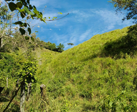
2025: First changes after fencing. Picture: Antonio Coronado
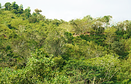
2026: Further land changes. Pictures: Rodrigo Cámara-Leret
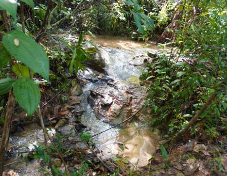
Picture of the stream that runs through the plot in Feb-2026
Thanks to the research conducted by several of the young people and leaders on the field team, they are highly skilled in using various tools that have enabled them to map the sacred sites.